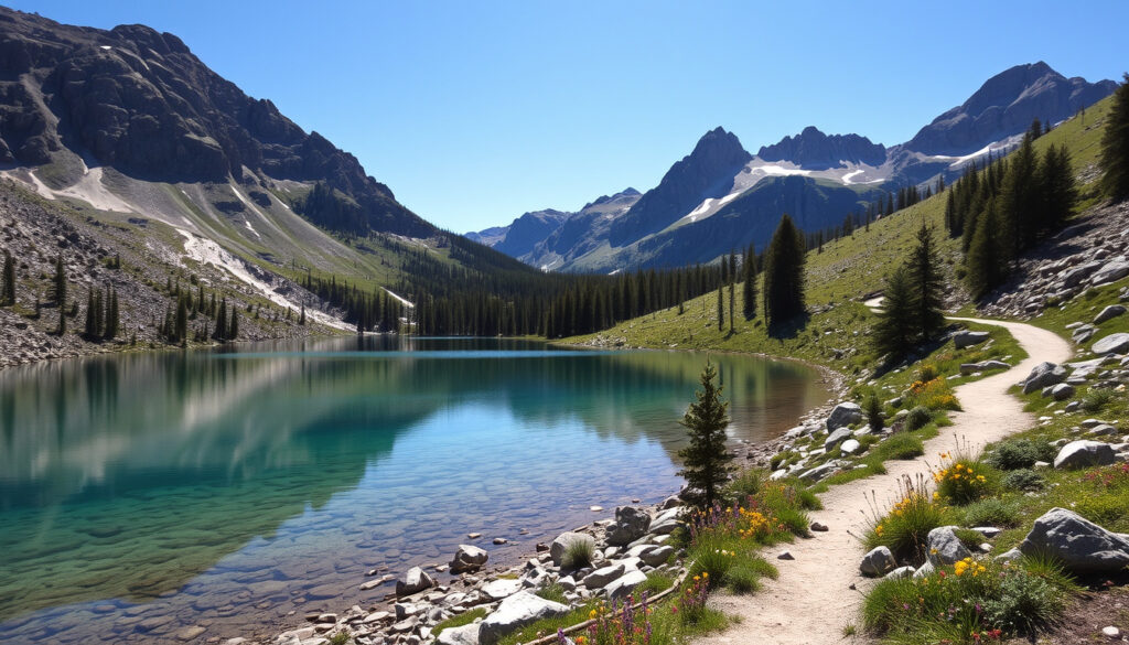
Diamond Lake and Rocky Mountain Track: Complete Hiking Guide
There’s a moment near the top of the Rocky Mountain Summit Track where Diamond Lake shrinks to a glittering coin below, and the whole arc of Lake Wanaka opens behind it — proof that a short drive from town can deliver a serious alpine payoff. This guide walks you through the three distinct ways to explore the Diamond Lake Conservation Area, from a 45-minute lakeside stroll to the full, challenging loop that links both trails, with verified data from the Department of Conservation and real-world feedback from hikers who’ve been there.
Distance: 4.8 miles (7.7 km) loop ·
Elevation gain: 775 meters (2,543 ft) ·
Duration: 3 hours return (Rocky Mountain Summit Track) ·
Difficulty: Challenging (combined loop); Easy to intermediate (Rocky Mountain Track only) ·
Location: Diamond Lake Conservation Area, 18.5 km west of Wanaka, Mount Aspiring Road ·
Best time: October to April (spring through autumn)
Quick snapshot
- Trailhead is at Diamond Lake Conservation Area, 18.5 km west of Wanaka on Mount Aspiring Road (Department of Conservation (New Zealand government agency))
- Rocky Mountain Track is a 7 km loop with an easy to intermediate grade (Wānaka NZ (official visitor guide))
- Diamond Lake Circuit Track is 2.5 km return and takes 45 minutes (Earth Trekkers (independent travel guide))
- No dogs permitted in the conservation area (Tobinka (independent hiking guide))
- Exact trail conditions in the current season — check DOC for alerts (AllTrails (user-generated hiking platform))
- Whether the Diamond Lake loop is fully accessible year-round in wet weather (AllTrails (user-generated hiking platform))
- Difficulty rating varies between sources — DOC says easy to intermediate, Wanaka NZ says moderate-hard, user reviews say challenging (AllTrails (user-generated hiking platform))
- Track published distance estimates vary by source (DOC says 7 km; some guides report 6.8–9.6 km depending on route choices) (TripAdvisor (user-generated travel reviews))
- Plan your visit during spring through autumn (October–April) for best conditions (Walk My World (hiking guide))
Where is the Diamond Lake and Rocky Mountain track located?
Both walks start from the same gravel car park, tucked against the edge of the Diamond Lake Conservation Area on Mount Aspiring Road. The drive from central Wanaka takes about 20 minutes along a sealed road that winds alongside the Clutha River before climbing toward the lake basin.
Getting to the Diamond Lake car park from Wanaka
- Distance from Wanaka: 18.5 km along Wānaka-Mt Aspiring Road (Department of Conservation (New Zealand government agency))
- Drive time: Approximately 20 minutes (Earth Trekkers (independent travel guide))
- Road surface: Sealed all the way to the car park
- Signage: Clear brown DOC signs at the turnoff and at the trailhead
Parking and facilities at Diamond Lake Conservation Area
- Car park: Gravel lot with space for approximately 20–30 vehicles
- Toilets: Available at the trailhead (Department of Conservation (New Zealand government agency))
- Cell reception: Limited to none on the track
- No drinking water available — bring your own
The car park fills early on summer weekends (December–February). Arrive before 9 a.m. or plan for a midday arrival when morning hikers are returning. There is no overflow parking on Mount Aspiring Road.
The implication: The trailhead is easily accessible for anyone based in Wanaka, but the limited parking means timing matters — especially between November and March when visitor numbers peak.
How long and how challenging is the Diamond Lake and Rocky Mountain track?
The answer depends entirely on which route you choose. Three distinct options share the same starting point, and their profiles differ sharply. One pattern: as the distance grows, the difficulty jumps faster than you might expect.
| Route | Distance | Elevation gain | Duration | Difficulty (DOC grade) |
|---|---|---|---|---|
| Diamond Lake loop | 2.5 km return | ~100 m | 45 min | Easy (Wānaka NZ (official visitor guide)) |
| Diamond Lake Lookout | 2 km return | ~100 m | 1 hour | Easy-moderate (Wānaka NZ (official visitor guide)) |
| Lake Wanaka Lookout | 5 km return | ~200 m | 2 hours | Easy-moderate (Wānaka NZ (official visitor guide)) |
| Rocky Mountain Summit Track | 7 km loop | 520–775 m (varies by source) | 3 hours | Easy to intermediate (Department of Conservation (New Zealand government agency)) |
| Combined Diamond Lake & Rocky Mountain track | 7.3–9.6 km | 520–775 m | 3–4 hours | Challenging (Earth Trekkers (independent travel guide)) |
Distance and elevation gain for the full loop
- DOC officially lists the Rocky Mountain Track as a 7 km loop with a 3-hour return time (Department of Conservation (New Zealand government agency))
- Earth Trekkers reports the combined route at 7.3 km roundtrip with a 520 m ascent (Earth Trekkers (independent travel guide))
- Walk My World records an 8 km distance with 500 m elevation gain (Walk My World (hiking guide))
- A trail-running site lists the loop at 9.6 km with 680 m ascent, showing that route choices and navigation can stretch the distance (Running Wild NZ (trail-running resource))
Difficulty rating for the Rocky Mountain Summit Track
- DOC grades it as “easy to intermediate” — the second tier of New Zealand’s six-grade walking track system (Department of Conservation (New Zealand government agency))
- Wānaka NZ categorizes the summit track as “moderate-hard” (Wānaka NZ (official visitor guide))
- The Diamond Lake Lookout section is rated “easy-moderate with lots of stairs” (Wānaka NZ (official visitor guide))
What can I see on the Diamond Lake loop and Rocky Mountain Summit Track?
The scenery shifts in layers as you ascend. What starts as a sheltered lake walk turns into a high-country ridge traverse with views that stretch across the Upper Clutha Basin.
Diamond Lake Lookout and views
- The Diamond Lake Lookout sits roughly 1 km from the car park and offers reflections of the lake against the granite bluffs of Hospital Flat (Wānaka NZ (official visitor guide))
- The short loop circles the lake through beech forest and wetland boardwalks (Department of Conservation (New Zealand government agency))
- Lookout point involves a steep staircase with roughly 200 wooden steps
Rocky Mountain summit panorama
- The summit sits at approximately 775 m above sea level (Department of Conservation (New Zealand government agency))
- Views encompass Diamond Lake, Lake Wanaka, the Matukituki Valley, and Mount Aspiring on clear days (Department of Conservation (New Zealand government agency))
- The ridge walk connects multiple viewpoints including Lake Wanaka Lookout (5 km return, 2 hours, easy-moderate per Wānaka NZ) (Wānaka NZ (official visitor guide))
Diamond Lake and Hospital Flat area
- The Diamond Lake Conservation Area covers the Hospital Flat basin, a glacial valley with tussock grasslands
- Layers of schist rock formations define the lower slopes — visible from the lake edge and the lower track sections
- The route can be combined in a figure-eight style using multiple lookouts and loops (Earth Trekkers (independent travel guide))
The summit view is the payoff for the climb. Casual walkers satisfied with the lake-level loop will miss the ridgeline entirely. Anyone who skips the lake loop first, however, will walk past the area’s most accessible photo stop.
Which Wanaka walk should I choose: Diamond Lake loop, Rocky Mountain Summit Track, or both?
Since both trails start from the same car park, the question is not which one to drive to — it’s how much time and energy you have. Three options, three different outcomes.
Diamond Lake loop: 45 minutes, easy
- Distance: 2.5 km return (Wānaka NZ (official visitor guide))
- Time: 45 minutes
- Elevation gain: Minimal (approximately 100 m)
- Best for: Families with young children, casual walkers, photographers wanting lake reflections
- Surface: Gravel path and boardwalk, well-maintained
Rocky Mountain Summit Track: 3 hours, intermediate
- Distance: 7 km loop (Department of Conservation (New Zealand government agency))
- Time: 3 hours return
- Elevation gain: 520–775 m depending on exact route
- Best for: Hikers with moderate fitness, those seeking summit views without a full day commitment
- Surface: Gravel, rock steps, exposed ridge sections
Combined Diamond Lake and Rocky Mountain track: challenging, 4.8 miles
- Distance: 7.3–9.6 km (4.8 miles per some sources) depending on route choices (Earth Trekkers (independent travel guide))
- Time: 3–4 hours
- Elevation gain: 520–775 m
- Best for: Experienced hikers who want a full workout and multiple viewpoints
- Note: The figure-eight combination means you’ll cover the lake loop first, then ascend Rocky Mountain, returning via the ridge
The implication: Choosing the full combined route adds only about one hour over the summit track alone. If you have the fitness, the combined loop delivers both experiences with minimal extra distance — the lake loop is short enough to tack on without making a separate trip.
What do recent reviewers say about the Diamond Lake and Rocky Mountain track?
User reviews across platforms paint a consistent picture: the climb is rewarding, but the difficulty catches some by surprise. Here’s the sentiment breakdown from the main review sources.
Reviews from AllTrails and TripAdvisor
- AllTrails rating: 4.5+ stars based on hundreds of reviews, with the combined loop flagged as “challenging” by most users (AllTrails (user-generated hiking platform))
- TripAdvisor reviewers consistently mention steep sections and recommend sturdy footwear and plenty of water (TripAdvisor (user-generated travel reviews))
- Common praise: “Stunning views the whole way” and “worth every step”
- Common critique: “Steeper than expected” and “more like a moderate-hard walk than intermediate”
“The climb is relentless in places but the panorama from the top is unmatched among Wanaka’s short walks. Bring more water than you think you need.”
— TripAdvisor reviewer, October 2024
Reddit tips and common questions
- Reddit users on r/newzealand and r/Wanaka suggest starting early (before 8 a.m.) to avoid crowds and heat
- Several threads note the track is popular for birding and camping in the conservation area
- Users recommend boots and at least 1.5 liters of water per person for the summit track (Reddit (user discussion forum))
- Common question: “Is the Diamond Lake walk suitable for children?” — answer: the lake loop is fine for kids; the summit track is not recommended for young children
Several reviewers report the track can be slippery after rain. The rock steps on the ascent hold water, and the ridge sections have loose gravel near the edges. Check DOC for weather alerts before setting out.
The trade-off: User reviews are overwhelmingly positive about the views but consistently warn about the aerobic demand. Treat the official “easy to intermediate” grade as a minimum baseline, not a guarantee.
What should I bring for the Diamond Lake and Rocky Mountain track?
A short walk that climbs nearly 800 meters demands more than a casual stroll’s worth of gear. Here’s a practical packing list based on DOC recommendations and hiker experience.
Upsides
- Free entry and parking
- Well-marked trails — no navigation skills needed
- Multiple route options suit different fitness levels
- Toilet at trailhead
- Dogs are not allowed, which keeps the track quieter
Downsides
- Steep sections catch unprepared hikers off guard
- Limited parking on summer weekends
- No water available on the track
- Cell reception is unreliable — no way to call for help on the upper ridge
- Combined loop is 3–4 hours, which feels longer than its distance suggests due to elevation
Essential gear
- Footwear: Sturdy boots or trail runners with good grip — sections of the summit track have loose rock and exposed roots
- Water: At least 1.5 liters per person for the summit track or combined loop
- Sun protection: Hat, sunscreen, sunglasses — the ridge section has no shade
- Layers: The summit can be 5–10°C cooler than the car park, even in summer
- Rain jacket: Conditions change rapidly in this part of Otago
- Snacks: High-energy food for the climb
- Map: Download a map offline before you lose reception
“The walk to the summit of Rocky Mountain is of easy to intermediate difficulty and takes 3 hours return. The track climbs steadily through mixed beech forest to a ridge line that offers spectacular views of Lake Wanaka, Diamond Lake, and the Harris Mountains.”
— Department of Conservation, official track description
The implication: Packing for the summit track means preparing for conditions that change faster than the distance suggests. The 7 km loop feels more like a 10 km hike in terms of energy output.
How do I get to the trailhead from Wanaka?
The trailhead is easy to reach, but the directions rely on knowing the right turnoff. Here’s how to get there from Wanaka town center.
- From Wanaka town center, head west on Ardmore Street toward the lakefront
- Turn onto Mount Aspiring Road (signposted for Glendhu Bay, Treble Cone, and the West Coast)
- Drive 18.5 km along Mount Aspiring Road — the road runs alongside the Clutha River/Upper Clutha for much of the route
- Watch for the “Diamond Lake Conservation Area” sign on your left
- Turn into the gravel car park
seethesouthisland.com, churnewzealand.com, wanakaapp.nz, runningwildnz.com, wildernessmag.co.nz, theroadlesswritten.com.au, runningwildnz.com
Frequently asked questions
How long is the Diamond Lake loop walk?
The Diamond Lake loop is 2.5 km return and takes approximately 45 minutes at an easy pace (Wānaka NZ (official visitor guide)).
Do I need to book to hike the Diamond Lake and Rocky Mountain track?
No booking is required. The track is free and open year-round (Department of Conservation (New Zealand government agency)).
What is the elevation gain on the Diamond Lake loop?
The Diamond Lake loop has minimal elevation gain — approximately 100 meters. The climb to the Diamond Lake Lookout involves roughly 200 wooden steps but is not sustained (Wānaka NZ (official visitor guide)).
Are there toilets at the Diamond Lake car park?
Yes, there are public toilets at the trailhead car park (Department of Conservation (New Zealand government agency)).
Can I camp at Diamond Lake Conservation Area?
No camping is permitted within the conservation area. The nearest camping options are at Glendhu Bay or Lake Hawea, both within a 20-minute drive (Department of Conservation (New Zealand government agency)).
Is the Rocky Mountain Summit Track suitable for beginners?
DOC rates it easy to intermediate, but most user reviews describe sections as moderately challenging. Beginners should start with the Diamond Lake loop and assess their fitness before attempting the summit (Department of Conservation (New Zealand government agency)).
What is the best time of day to hike the Diamond Lake and Rocky Mountain track?
Early morning (before 9 a.m.) for summer parking availability and cooler temperatures. Mid-afternoon in autumn and spring offers good light for photography. Avoid late afternoon in winter (June–August) as the track loses sun early (Earth Trekkers (independent travel guide)).
More related posts
 FNAF 2 Movie: Age Rating, Release & Parent Guide
 How Long Does COVID Last? 2025 Recovery Timeline
 What Is NFC on My Phone? Should You Keep It On or Off?
 South Africa vs England Rugby 2026: Channel, Score & Watch Live
 NZ Dollar in Indian Rupees: Live NZD to INR Rate Today
 Best Women’s Winter Coats NZ: Top Picks & Buying Guide
 Ed Sheeran Tickets NZ – 2026 Loop Tour Dates, Venues, Buying Guide
 Cheap Unlimited Mobile Plans Ireland: €12.99 Deals