Auckland Coast to Coast Walk: Route Map, Distance & Guide
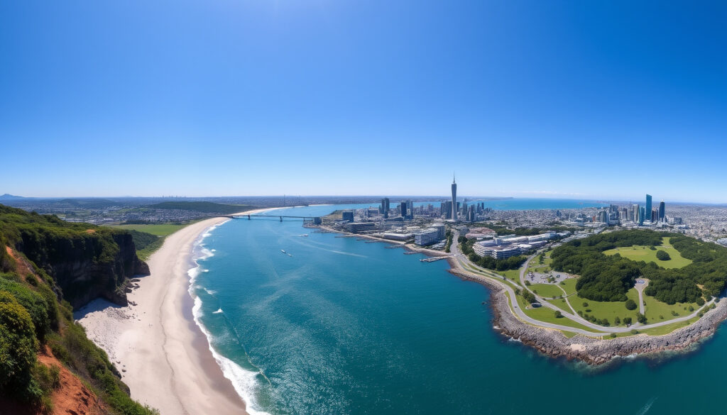
Auckland packs volcanoes, beaches, and bush into a slender strip of land — and crossing that isthmus on foot is the most direct way to feel its geographic oddness. The Auckland Coast to Coast Walk covers 16km from Waitematā Harbour (Pacific side) to Manukau Harbour (Tasman side), tracing paths shaped by 600 years of Māori occupation. The route forms the urban section of Te Araroa, New Zealand’s 3,000km national trail, and requires no permits, fees, or special gear to complete.
Distance: 16 km · Elevation Gain: 1,312 ft · Estimated Time: 4.5–5 hours · Difficulty: Moderate · Starting Point: Waitematā Harbour
Quick snapshot
- 16 km total from official and trail sources (Herenga Ā Nuku)
- Exact annual participant numbers — unverified
- Parking availability variations by season — unverified
- Māori used this isthmus for canoe portages centuries before European arrival — based on Herenga Ā Nuku track notes
- New pedestrian bridge at Onehunga links the route to Mangere — noted in Herenga Ā Nuku PDF map
Key specifications come from Auckland Council, Herenga Ā Nuku, and GPS-based trail tracking databases — the table below summarizes the official figures alongside the most commonly cited crowd-sourced values.
| Detail | Value |
|---|---|
| Length | 16 km (10 miles) |
| Duration | 4.5–5 hours |
| Difficulty | Moderate |
| Elevation | 1,312 ft |
| Harbour endpoints | Waitematā to Manukau |
| Part of | Te Araroa Trail (3,000 km total) |
How long is the Coast to Coast walkway in Auckland?
The core route spans 16 km, according to the Department of Conservation and multiple trail databases. Sources vary slightly — Auckland Council lists 15.5 km, while AllTrails records 16.4 km — but 16 km is the figure most commonly cited by walkers and official sources.
Distance details
- The walk connects Waitematā Harbour (Pacific Ocean side) to Manukau Harbour (Tasman Sea side) across Auckland’s narrowest point
- The isthmus is less than 2 km wide east-to-west at its narrowest, and less than 9 km north-to-south
- Adding transport to/from endpoints can push the total to 17 km or more on some mapping platforms
Elevation profile
Vertical gain sits at approximately 400 m (about 1,312 ft), according to Fastest Known Time (a GPS-based trail tracking platform). The most demanding stretch comes when walkers tack on the optional out-and-back to One Tree Hill summit, which adds extra elevation but rewards you with panoramic views of the Hauraki Gulf and Rangitoto Island.
How hard is the coast to coast walk for beginners?
The walk carries a “moderate” difficulty rating, which means it’s manageable for fit beginners but not a casual stroll. The terrain mixes sealed city footpaths with gravel tracks through parks and volcanic cones — comfortable shoes with good support are essential rather than hiking boots.
Difficulty rating
Auckland NZ (the regional tourism body) describes the route as requiring “moderate to high fitness for the full 16 km.” The catch is that city walkers unused to sustained walking will feel it in their legs by the final stretch, even if they never leave the footpath.
Terrain challenges
- Mt Eden (Maungawhau) and One Tree Hill (Maungakiekie) both involve sustained climbs
- Cornwall Park has uneven ground in places
- Urban sections (Quay Street, Queen Street) require navigating foot traffic
Fit beginners can complete this walk comfortably, but first-timers should train with a 10–12 km walk beforehand. Attempting the full 16 km cold is the surest way to a miserable finish.
What is the coast to coast walk in New Zealand?
The Auckland Coast to Coast Walk is an urban walkway that traverses the Auckland isthmus from one coast to the other. It forms the city section of the Te Araroa Trail, New Zealand’s 3,000 km long-distance path that runs from Cape Reinga in the north to Bluff in the south.
Route overview
Auckland Council divides the walk into three sections: City to Domain (50 minutes), Grafton to One Tree Hill (90 minutes), and One Tree Hill to Onehunga. The route passes through Auckland Domain, climbs toward Maungakiekie, loops Cornwall Park, and descends through Jellicoe Park before ending at Onehunga Bay Reserve.
Historical context
Before European settlement, Māori used this isthmus for canoe portages between the two harbours — a natural shortcut between the Pacific and the Tasman. The Herenga Ā Nuku track notes that Māori shaped these landscapes over 600 years, and many of today’s parks occupy former Māori garden and settlement sites.
The walk isn’t just a fitness challenge — it’s a corridor through living history. Each volcanic cone carries significance beyond its views.
How fit do you need to be to walk the Coast to Coast?
Moderate fitness is the baseline. You don’t need to be a runner or a regular hiker, but you should be comfortable walking 3–4 hours continuously with some climbing. The route rewards consistent pace over sprinting — most walkers who bonk out do so because they started too fast or didn’t bring enough water.
Fitness requirements
- Able to walk 10+ km without stopping for extended periods
- Comfortable climbing 200–400 m elevation (not necessarily running)
- No major joint issues — the descents off the volcanic cones stress knees
Training tips
Build volume progressively: start with 8 km walks at your intended pace, add a weighted backpack (5–8 kg) in week two, and tackle a hill-repeats session on Mt Eden or a similar local hill two weeks out. Plan My Walk (a New Zealand trail planning tool) can help you map local training routes that mirror the terrain.
How long does the Auckland coast to coast walk take?
Most walkers complete the core trail in 4.5–5 hours at a moderate pace, according to The Road Less Written (an Australian hiking blog with detailed Auckland coverage). Adding stops for photos, detours to Mt Eden or Albert Park, or lunch breaks pushes this to 6–7 hours. A full day is advisable if you want to explore the optional sidetrips.
Time estimates
- Fast walkers (5+ km/h pace): 3.5–4 hours
- Average walkers: 4.5–5 hours
- Leisurely pace with sightseeing: 5.5–7 hours
Factors affecting pace
Trail conditions matter less than you’d think — the path is well-maintained throughout. What slows walkers most is poor shoe choice (blisters), insufficient food (hypoglycaemia hitting at hour 3), and getting lost at Cornwall Park if you miss a marker. Auckland Council’s official page confirms the signage uses blue markers for one direction and yellow Te Araroa markers for southbound walkers, but hikers still report using Google Maps alongside the physical markers.
How to walk the Coast to Coast: step-by-step
These steps follow the most practical direction for first-timers: starting from the Waitematā side and walking toward Manukau. This lets you tackle the hardest climbs (Mt Eden, One Tree Hill) early while your legs are fresh, and finish with the gentler waterfront descent at Onehunga.
- Start at Viaduct Harbour or Princes Wharf. Park near the CBD, catch the train from Britomart to Onehunga, then walk back — or start at the Viaduct and walk one-way. The Herenga Ā Nuku PDF map shows the precise Princes Wharf connection point.
- Follow Quay Street south, then Queen Street inland. The city section is the least scenic but the most practical — you’ll pass the The Trek notes that this urban stretch is the easiest leg to navigate if you’re using Google Maps alongside the trail markers.
- Enter Auckland Domain and climb toward Grafton. Auckland Council estimates this first leg takes 50 minutes. The domain’s western slope leads you toward Grafton, where the climb toward the volcanic cones begins in earnest.
- Scale Mt Eden (Maungawhau) — an optional detour with big views. The summit detour is short but steep. If you’re skipping it, keep heading southeast on the well-marked path toward Cornwall Park. The views from the top include Rangitoto Island and most of the Hauraki Gulf.
- Pass through Cornwall Park toward One Tree Hill (Maungakiekie). The park is a pleasant mid-route stretch, but don’t miss the One Tree Hill loop — the summit is the highest point on the walk. The Fastest Known Time GPS track notes that the summit out-and-back is a separate detour from the main car-park loop.
- Descend through Jellicoe Park to Onehunga. The final park section is the easiest terrain — flat, shaded, and well-signed. You’ll pass through to Onehunga Bay Reserve, where bathrooms and a Māori carving are waiting.
- End at Taumanu Reserve or cross the new pedestrian bridge to Mangere. Herenga Ā Nuku highlights the new pedestrian bridge linking Onehunga to Mangere as a recent addition worth knowing about.
Starting at the CBD means tackling Mt Eden and One Tree Hill first — ideal for fitness — but it also means the dramatic Onehunga finish is anticlimactic if you’re exhausted. Starting at Onehunga gives you a waterfront opener but climbs into the hills at the end when your legs are gone.
What to bring
The list is straightforward: comfortable trail or walking shoes, 1.5–2 litres of water, snacks for two or three stops, sunscreen, a rain jacket (Auckland weather is unreliable), and a fully charged phone with the route loaded offline. A hat and sunglasses round out the essentials.
Upsides
- Well-signed path with blue and yellow markers
- No special permits or fees required
- Free to walk at any time
- Public transport access at both endpoints
- Printable maps and GPX files available from official sources
Downsides
- Long urban stretches can feel disconnected
- Some road crossings near the CBD are busy
- Limited shade on the volcanic cone sections
- One Tree Hill summit loop adds time and elevation if you take it
- No water refill points between Onehunga and the CBD
Wildlife and scenery along the route
For an urban walk, the Coast to Coast packs surprising natural variety. Auckland Council’s official page lists native birds you’re likely to spot: kōtare (kingfisher), pīwakawaka (fantail), tūī, and kererū (wood pigeon). The volcanic cones — remnants of Auckland’s volcanic field — provide unusual geology for a city centre walk.
The Auckland Council guide notes that the walk passes through landscapes shaped by 600 years of Māori occupation, and the parks occupy former garden and settlement sites. Onehunga Bay Reserve has a notable Māori carving and hosts a tradition of water-dipping at the waterfront — a meaningful finish if you know to look for it.
“It is the easiest way to say you have walked across the country!”
— The Road Less Written (Hiking Blogger)
“The impressive 16 km Coast to Coast Walkway connects the regions Waitematā and Manukau Harbours.”
— Auckland NZ (Tourism Site)
Maps, GPS, and navigation resources
The most reliable maps come from Herenga Ā Nuku (Auckland’s parks agency) as a downloadable PDF, and from Plan My Walk (a New Zealand trail planning platform). For GPS tracks, the Fastest Known Time database has GPX files for the route including the One Tree Hill summit detour.
Google Maps and AllTrails are widely used by walkers despite the signage, according to The Road Less Written. The DOC Visitor Centre at Shed 19, Princes Wharf also stocks printed materials for those who prefer physical maps.
The implication: digital and physical navigation tools complement each other. The official maps give you route confidence; the GPS tracks handle elevation detail; and a loaded phone map is your safety net in the city sections where trail markers can be easy to miss.
Related reading: Stone and Water World Auckland Guide · Houses for Sale in Auckland
Frequently asked questions
How much does the coast to coast walk cost?
The walk itself is free. There are no entry fees, no permit costs, and no charge for parking in most public areas near the endpoints. Costs only arise if you pay for parking in private CBD car parks or take public transport — a train from Britomart to Onehunga costs a few dollars each way.
Where is the Auckland coast to coast walk route map?
The official PDF map comes from Herenga Ā Nuku. Plan My Walk also hosts an interactive map, and Fastest Known Time provides downloadable GPX files.
Is the Auckland coast to coast walk part of Te Araroa?
Yes. The walk forms the urban section of the Te Araroa Trail, New Zealand’s 3,000 km national long-distance trail. Te Araroa markers in yellow guide southbound walkers throughout the route.
What should I bring on the Auckland coast to coast walk?
Comfortable walking shoes, 1.5–2 litres of water, snacks, sunscreen, a rain jacket, and a phone with the route loaded offline. A hat, sunglasses, and a basic first aid kit are sensible additions for a 5-hour outing.
Can I do the Auckland coast to coast walk in one day?
Yes. Most walkers complete the route in 4.5–5 hours, making a full-day walk entirely feasible. An early start ensures you finish before sunset, especially in the shorter days of autumn and winter.
Are dogs allowed on the Coast to Coast walkway?
Dogs on leads are permitted in most park sections but restrictions apply in certain areas, particularly near One Tree Hill during lambing season. Check Auckland Council’s current dog access rules before setting out.
What weather to expect on Auckland coast to coast walk?
Auckland’s weather is notoriously changeable. Expect sun, wind, and rain in any single outing — a light rain jacket is the single most practical item. Summer days can be hot on the exposed volcanic cones; winter walks are cooler but shorter days mean an earlier finish is needed.
More related posts
 Prezzy Card Balance Check: Online Login & Phone Guide
 Grab a Seat NZ: Air New Zealand Grabaseat vs Jetstar
 Portable CD Player NZ: Be t Pick , Price & Shopping Guide (2026)
 Homes for Sale in Rotorua: Listings, Private Sales & By Owner
 How Old Am I? Exact Age Calculator by Date of Birth
 Mitre 10 Mega Palmerston North – Hours, Address, Phone Guide
 Arsenal F.C. vs Crystal Palace F.C. Timeline: H2H History
 Evo Cycles Lower Hutt – 250+ Bikes and Repair Services